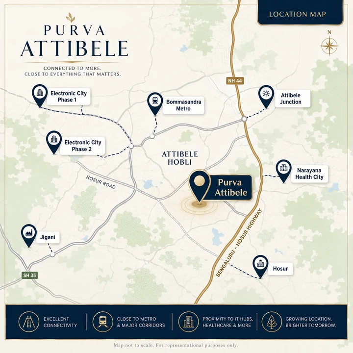
Macro Position — Bengaluru's Southern Threshold
Hosur Road is one of the few Bengaluru corridors where the employment base does not stop at the city limit. Running south from Silk Board, it passes Electronic City — Infosys, Wipro, Biocon, TCS, HCL and one of India's largest IT clusters — then Bommasandra and Jigani's industrial estates, then Attibele at the NH-44 intersection, and then crosses into Tamil Nadu at Hosur.
Hosur is not a suburb. It is a manufacturing city in its own right, built on TVS, Ashok Leyland, Titan and Caterpillar, with a fast-growing electronics and EV component cluster. It has its own labour market, its own housing demand and its own growth trajectory — and it sits ten kilometres from Attibele.
That dual-economy position is the location's structural argument. A residential corridor tied to a single industry inherits that industry's hiring cycle. When IT services slow, purely IT-dependent Bengaluru micro-markets slow with them. Attibele draws buyers and tenants from IT services to the north and manufacturing to the south, in two states, on different cycles. It is a materially more diversified demand base than most Bengaluru peripheral markets carry.
Micro Position — Why Attibele Hobli
On the name. A hobli is a revenue sub-division within a taluk in Karnataka's administrative structure. Attibele Hobli sits inside Anekal Taluk in the Bengaluru Urban district. It is the precise regulatory phrasing Puravankara used in its own December 2025 disclosure of the 53.5-acre land acquisition, and it is the correct way to describe the project's location in a legal or approvals context.
The pricing position. Attibele apartments average ₹6,450 per sq ft with a range of ₹5,250–₹7,800. Electronic City averages ₹7,400, spanning ₹5,450 to ₹10,250. Attibele is the corridor's affordability anchor — meaningfully cheaper than Electronic City for a location that is 12 to 15 km away from it.
The supply gap. What Attibele has almost none of is branded high-rise product. The existing stock is mid-rise and largely locally developed. There is no flagship podium township from a national listed developer anywhere on this stretch. Purva Attibele's fourteen towers to 80 metres would be the tallest and largest branded residential development on the road by a wide margin.
The infrastructure trigger. Namma Metro's Yellow Line is operational to Bommasandra, connecting the Electronic City belt to the network for the first time. A further Hosur Road extension with a proposed station at Attibele would put the corridor directly on the map. For buyers already comfortable with the Puravankara name, Purva Weaves adds a local portfolio lens without skipping the practical checks around cost and daily use.
Road Connectivity
| Route | Detail |
|---|---|
| NH-44 / Hosur Road | The corridor's primary spine. Attibele sits at the NH-44 intersection, roughly 2 km from the project. Runs north to Electronic City, Silk Board and the city; south to Hosur and onward to Krishnagiri and Salem. |
| Bangalore Elevated Tollway (BETL) | The elevated expressway between Koramangala and Electronic City. It bypasses the Silk Board bottleneck entirely, which is the single biggest determinant of a Hosur Road commute time into central Bengaluru. |
| Attibele–Sarjapur Road | The east-west link from Attibele to Sarjapur, and onward to the Sarjapur Road corridor and Whitefield. Opens up the eastern employment belt from a southern address. |
| NICE Road | Peripheral ring linking Hosur Road to Bannerghatta Road, Kanakapura Road, Mysore Road and Tumkur Road without entering the city. Interchange approximately 14 km. |
| Outer Ring Road | Reached via Hosur Road at Silk Board, connecting to the Bellandur, Marathahalli and HSR employment nodes. |
| Anekal Road | Local link west to Anekal town and the Jigani industrial belt. |
On the Silk Board question. Any honest assessment of a Hosur Road address has to address Silk Board Junction, historically one of Bengaluru's worst traffic bottlenecks. The Bangalore Elevated Tollway is the answer for most journeys — it carries traffic from Electronic City over the congested stretch. For an Attibele resident travelling to central Bengaluru, the elevated expressway is the route that makes the commute viable.
Metro Connectivity
| Line / project | Status | Relevance |
|---|---|---|
| Yellow Line — Bommasandra terminus | Operational | Approximately 10 km from the project. Connects the Electronic City belt to the Namma Metro network for the first time, running north via Electronic City, Hosa Road, HSR Layout and Jayadeva to Silk Board and RV Road. |
| Yellow Line — Electronic City stations | Operational | Direct metro access to the Electronic City campuses from the corridor. |
| Proposed Hosur Road extension | Proposed | A metro extension along Hosur Road with a proposed station at Attibele would put the corridor directly on the network. Proposed, not funded and under construction. |
The Yellow Line reaching Bommasandra is the most consequential recent infrastructure event on this corridor. It changes the Electronic City commute from a road-only proposition to a rail one, and it establishes the precedent for extending further south. A resident today drives to Bommasandra and boards; a resident after an Attibele extension would board locally.
Underwrite the purchase on what exists — the operational Yellow Line at Bommasandra and the elevated expressway. Treat the Attibele station as an option with real value if exercised.